- Posts: 12446
- Thank you received: 1029
- Forum
- Open Forum
- Miscellaneous Research Topics
- General Airfield or 20th Century Military Architecture Discussion Topics
- Unknown airfield sites from a 1946 list
Unknown airfield sites from a 1946 list
- Peter Kirk
-
 Topic Author
- Offline
- Moderator
-

Less
More
13 Dec 2014 16:02 #1
by Peter Kirk
No Amount Of Evidence Will Ever Persuade An Idiot (probably not Mark Twain)
Unknown airfield sites from a 1946 list was created by Peter Kirk
The list below was extracted from AIR 20/7260 and features a list of airfields that I have either not come across or their wartime use is sketchy. I know there are some that have been discussed on this forum, and I doubt this adds little other than it confirms they were requisitioned. Others may be aborted new airfields or early war ELGs. Some may have been used as scatter fields or by training units but not recorded or little used. I think there may be some ALG sites that were never built and possibly potential Class A ones. It is also possible that some were used for other purposes once requisitioned but retained the airfield connection to cause it to be on this list.
I haven't yet followed any of these up but I did check Scopwick Moor as it rang a bell, now was it Digby or Sealand? Anyway it was north of Digby airfield and since Digby was pre-war I can only guess that it was for an expansion proposal as it is far too close for a separate airfield.
Have fun and I await the replies, including my own
I haven't yet followed any of these up but I did check Scopwick Moor as it rang a bell, now was it Digby or Sealand? Anyway it was north of Digby airfield and since Digby was pre-war I can only guess that it was for an expansion proposal as it is far too close for a separate airfield.
Have fun and I await the replies, including my own
| Consolidated Statement on the use of RAF Airfields March - May 1946 | |
| AIR 20/7260 | |
| All those below were listed as grass and were listed Requistioned and later De-Requisitioned unless otherwise noted | |
| * Entries that were unreadable of partly obscured by a hole punch | |
| AIRTH | 86 acres de-reqn'd 16/7/1941 |
| BALL HALL | De-reqn'd 11/11/1943 |
| BALL HILL (Bath Racecourse) | De-reqn'd ??/7/1945 |
| BIRDHAM | 331 acres de-reqn'd 9/3/1943. Not proceeded with. |
| BOGLE BURN | 236 acres de-reqn'd 3/2/1943 |
| BRAUNCEWELL | Hiring was terminated 24/6/1944 |
| BURFORD | 135 acres |
| CAITMANS FARM | 20 acres de-reqn'd 7/2/1943 |
| CAIRN BEG | To be leased by hiring but camcelled 24/11/1945 |
| COLD KIRBY | 182 acres de-reqn'd 26/4/1946 |
| CORSECOMBE | 116 acres de-reqn'd 30/12/1942 |
| CROSS KIRK | 145 acres |
| DERSINGHAM | 189 acres |
| FOREST FARM | 225 acres |
| GREAT CASTERTON | 148 acres |
| GREAT SHEFFORD | 171 acres |
| HAROLDSTON WEST | 113 acres |
| HARPLEY COMMON | 151 acres |
| HATCHGATE | |
| HATFIELD CHASE | |
| HERONFIELD* | Noted as allocated to FTC |
| HIGHTREE FARM | To be de-reqn'd in 1946 |
| HOCKWOLD | |
| HYKEHAM | |
| KIRKBY MALLORY (STAPLETON) | |
| LIMEKILNS(SIDEHILL) | |
| LISBURN (NI) | |
| LITTLEWORTH | |
| LOWER REEDING | |
| LUDBOROUGH | |
| MANNINGFORD | |
| MARCROSS | |
| MARSKE | |
| MAXSTOKE | To be de-reqn'd in 1946 |
| NORMANTON | |
| NORTH STOKE | |
| OLD SODBURY | |
| OXNEY FARM | Purchased but handed back to WO |
| PLAINVILLE | |
| PUSSEY | Transferred to MAP |
| RABURNFOOT | Could this be Burnfoot? |
| RAGDALE | Not noted as being the bombing range. |
| ROSEVIDNEY | |
| SANDOWN | |
| SANDRIDGE | |
| SCOPWICK MOOR | |
| SNELSTON | |
| SOBERTON | |
| SOLLAS* | De-reqn'd 1943 |
| SOMERSHAM | De-reqn'd 19/2/1946 |
| STURTON | |
| TADCASTER | |
| TAKELEY | |
| TEHIDY | |
| TEMPLE GUITING | Noted as allocated to FTC |
| TURKDENE | |
| WAKEFIELD | |
| WALLYS FIELD | Noted as allocated to FTC |
| WALTHAM ST LAWRENCE | Noted as allocated to FTC |
| WANSFORD | Noted as allocated to FTC and to be de-reqn'd. |
| WATERLOOVILLE | |
| WEST LITTLETON DOWN | |
| WHITE ACRE HALL | De-reqn'd March 1946 |
| WHITTON MAWR | |
| WHITWELL | |
| WICK (ST BRIDES MAJOR) | |
| WINCANTON | |
| WINTERBOURNE STOKE | |
| WINTERBOURNE THOMSON | |
| WOLVERY | |
| YEARNGILL |
No Amount Of Evidence Will Ever Persuade An Idiot (probably not Mark Twain)
Please Log in or Create an account to join the conversation.
- Ossington_2008
- Offline
- Platinum Member
-

Less
More
- Posts: 1645
- Thank you received: 163
13 Dec 2014 17:22 #2
by Ossington_2008
Replied by Ossington_2008 on topic Unknown airfield sites from a 1946 list
Nice one. Wasn't Hatfield Chase to become Lindholme and Plainville to become York (Clifton)? Pussey looks like a typo for Pusey (Oxon) didn't that become an the SLG at Bush Barn, or something like that around that way? Oh for some co-ordinates or corroborating detail. There are six Sturtons, all either Notts or Lincs and 24 Normantons, though I suspect the one near to Bottesford looks warmest. Keep digging.
Please Log in or Create an account to join the conversation.
- carnaby
-

- Offline
- Platinum Member
-
Less
More
- Posts: 5026
- Thank you received: 440
13 Dec 2014 17:48 #3
by carnaby
Plan A is always more effective when the problem you are working on understands that Plan B will involve the use of dynamite
Replied by carnaby on topic Unknown airfield sites from a 1946 list
I'd a feeling that I'd heard of Sollas. There's one in the Hebrides which features a beach landing event occasionally
Noted that the spelling and location seems to vary, as do several other Scottish sites in this area. Location
Noted that the spelling and location seems to vary, as do several other Scottish sites in this area. Location
Plan A is always more effective when the problem you are working on understands that Plan B will involve the use of dynamite
Please Log in or Create an account to join the conversation.
- Kevin Aeronca old
- Offline
- Senior Member
-

Less
More
- Posts: 234
- Thank you received: 9
13 Dec 2014 18:27 #4
by Kevin Aeronca old
Replied by Kevin Aeronca old on topic Unknown airfield sites from a 1946 list
Wild guess, but how about Brauncewell and Normanton being SLGs for Cranwell? This Normanton is 4 miles SW of Cranwell and there's a suitable strip of land visible on GE just to the East. The 1945 survey photos might give a clue. And Scopwick is not a million miles from Cranwell, either.
Please Log in or Create an account to join the conversation.
- CornwallPhil
-

- Offline
- Elite Member
-

Less
More
- Posts: 870
- Thank you received: 163
13 Dec 2014 18:50 #5
by CornwallPhil
Replied by CornwallPhil on topic Unknown airfield sites from a 1946 list
I recognise two of the names in the list as being in Cornwall:
Rosevidney, which is a Manor house and farm along a lane that runs parallel to the Paddington-Penzance mainline between St Erth and Crowlas. wtp2.appspot.com/wheresthepath.htm?lat=5...grat=None&rgrat=None Its possible the fields could have been a landing ground but I have never heard of it nor have any of the locals mentioned it to me when I was investigating the St Erth POW camp or the GPO/RSS wireless listening station in the village. It's possible with the Commandos in St Ives or the Yanks in Marazion/Penzance there was a landing strip but again I've heard nothing to suggest that.
Tehidy, which is now a country park where the large house used to be a TB sanatorium. wtp2.appspot.com/wheresthepath.htm?lat=5...grat=None&rgrat=None Its very close to the decoy site for RAF Portreath Its possible it could have been utilised as an ELG for Portreath. The fields on the seaward side of the road were trenched in the summer of 1940 to prevent a landing taking place, although were filled in again later in the war in case anything from Portreath crash-landed, so could it refer to that? But locals refer to them as North Cliff rather than Tehidy which they see as the woods, farm & house. There were AA batteries at Carvannel Downs.
PS Before the new Sector Operations Room was built at Tregea (W of Portreath) it did operate for a while in a barn at Tehidy Barton which could be it. That was operational from 10th May 1941 to July 1943.
Rosevidney, which is a Manor house and farm along a lane that runs parallel to the Paddington-Penzance mainline between St Erth and Crowlas. wtp2.appspot.com/wheresthepath.htm?lat=5...grat=None&rgrat=None Its possible the fields could have been a landing ground but I have never heard of it nor have any of the locals mentioned it to me when I was investigating the St Erth POW camp or the GPO/RSS wireless listening station in the village. It's possible with the Commandos in St Ives or the Yanks in Marazion/Penzance there was a landing strip but again I've heard nothing to suggest that.
Tehidy, which is now a country park where the large house used to be a TB sanatorium. wtp2.appspot.com/wheresthepath.htm?lat=5...grat=None&rgrat=None Its very close to the decoy site for RAF Portreath Its possible it could have been utilised as an ELG for Portreath. The fields on the seaward side of the road were trenched in the summer of 1940 to prevent a landing taking place, although were filled in again later in the war in case anything from Portreath crash-landed, so could it refer to that? But locals refer to them as North Cliff rather than Tehidy which they see as the woods, farm & house. There were AA batteries at Carvannel Downs.
PS Before the new Sector Operations Room was built at Tregea (W of Portreath) it did operate for a while in a barn at Tehidy Barton which could be it. That was operational from 10th May 1941 to July 1943.
Please Log in or Create an account to join the conversation.
- Peter Kirk
-
Topic Author
- Offline
- Moderator
-
Less
More
- Posts: 12446
- Thank you received: 1029
13 Dec 2014 19:14 #6
by Peter Kirk
No Amount Of Evidence Will Ever Persuade An Idiot (probably not Mark Twain)
Replied by Peter Kirk on topic Unknown airfield sites from a 1946 list
I have a feeling Plainville was mentioned in "White Rose Base" so will dig out my much marked copy. If some never became airfields I suspect they were either de-reqn'd at the time or after the war. Oddly there are no dates after the letter "C".
I will check the alternative names mentioned in the replies lists in case both names were listed and if so it is probably safe to assume they were different sites. As with a lot of these records it a source of constant frustration that maps or grid refs are not included, even a county would help.
Looking at Hatfield Chase and Lindholme, the Chase itself is a couple of miles to the north of the airfield and Lindholme is mentioned separately as purchased and the bulk of these were requisitioned. Was it a "K" decoy site?
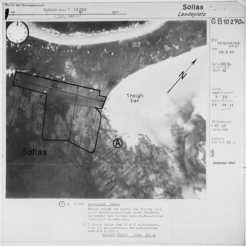
I had the same feeling about Sollas, assuming I interpreted the hole punch correctly, and I think is was via a German Luftwaffe aerial photo. The same, I think, with Sandridge.
I will check the alternative names mentioned in the replies lists in case both names were listed and if so it is probably safe to assume they were different sites. As with a lot of these records it a source of constant frustration that maps or grid refs are not included, even a county would help.
Looking at Hatfield Chase and Lindholme, the Chase itself is a couple of miles to the north of the airfield and Lindholme is mentioned separately as purchased and the bulk of these were requisitioned. Was it a "K" decoy site?
I had the same feeling about Sollas, assuming I interpreted the hole punch correctly, and I think is was via a German Luftwaffe aerial photo. The same, I think, with Sandridge.
No Amount Of Evidence Will Ever Persuade An Idiot (probably not Mark Twain)
Please Log in or Create an account to join the conversation.
- Peter Kirk
-
Topic Author
- Offline
- Moderator
-
Less
More
- Posts: 12446
- Thank you received: 1029
13 Dec 2014 19:54 #7
by Peter Kirk
No Amount Of Evidence Will Ever Persuade An Idiot (probably not Mark Twain)
Replied by Peter Kirk on topic Unknown airfield sites from a 1946 list
According to "White Rose Base" Plainville was an ALG for 58 Sqn's Whitleys in 1939/40. The last activity was 1941 when a Whitley crashed there (Z6660).
No Amount Of Evidence Will Ever Persuade An Idiot (probably not Mark Twain)
Please Log in or Create an account to join the conversation.
- OneEighthBit
-
- Offline
- Elite Member
-
Less
More
- Posts: 795
- Thank you received: 13
15 Dec 2014 20:29 #8
by OneEighthBit
Replied by OneEighthBit on topic Unknown airfield sites from a 1946 list
TEMPLE GUITING:
/community/showthread.php?8788-Temple-Guiting
TURKDENE: Actually Turkdean. Located at SP 10860 18229. Site cleared of obstructions but Northleach used instead. Site left marked as ELG but no longer marked as such after 1944. RAF returned in 1946 to rebuild walls but work was abandoned due to extreme winter and work not finished. Incomplete walls still in place.
BURFORD: SP 24035 11619. Made up of several fields to the west of Burford school. No idea of it's use or life span.
The above are all from various official documents/field visits/local research I did. Grid Ref's are the approximate centres of the landing ground. Both Turkdean and Burford formed an inverted "L" shape.
TURKDENE: Actually Turkdean. Located at SP 10860 18229. Site cleared of obstructions but Northleach used instead. Site left marked as ELG but no longer marked as such after 1944. RAF returned in 1946 to rebuild walls but work was abandoned due to extreme winter and work not finished. Incomplete walls still in place.
BURFORD: SP 24035 11619. Made up of several fields to the west of Burford school. No idea of it's use or life span.
The above are all from various official documents/field visits/local research I did. Grid Ref's are the approximate centres of the landing ground. Both Turkdean and Burford formed an inverted "L" shape.
Please Log in or Create an account to join the conversation.
- Peter Kirk
-
Topic Author
- Offline
- Moderator
-
Less
More
- Posts: 12446
- Thank you received: 1029
15 Dec 2014 21:04 - 08 Aug 2019 08:34 #9
by Peter Kirk
No Amount Of Evidence Will Ever Persuade An Idiot (probably not Mark Twain)
Replied by Peter Kirk on topic Unknown airfield sites from a 1946 list
A few links either in AiX or elsewhere that may or may not be correct.
Waltham St Lawrence
Great Shefford
Kirkby Mallory
Sollas is mentioned lower down the page also photo below.
I think Haroldstone West and Marcross were covered in one of the Ivor Jones Trilogy of Welsh airfield. They seemed to have included a lot of airfields I had never heard of before. I suspect the Wick (St Brides Major) would also have been covered but I don't recall it.
Marcross entry in Coflein states that it was a Q site originally and was used by US Army Cubs later
North Stoke - Confusing as the entry for Ball Hill is also on Bath Racecourse
Rosevidney
Soberton
Attached files
This image is hidden for guests.
Waltham St Lawrence
Great Shefford
Kirkby Mallory
Sollas is mentioned lower down the page also photo below.
I think Haroldstone West and Marcross were covered in one of the Ivor Jones Trilogy of Welsh airfield. They seemed to have included a lot of airfields I had never heard of before. I suspect the Wick (St Brides Major) would also have been covered but I don't recall it.
Marcross entry in Coflein states that it was a Q site originally and was used by US Army Cubs later
North Stoke - Confusing as the entry for Ball Hill is also on Bath Racecourse
Rosevidney
Soberton
Attached files
This image is hidden for guests.
Please log in or register to see it.
No Amount Of Evidence Will Ever Persuade An Idiot (probably not Mark Twain)
Last edit: 08 Aug 2019 08:34 by Peter Kirk. Reason: Broken link now corrected
Please Log in or Create an account to join the conversation.
- MikeO
- Offline
- Senior Member
-
Less
More
- Posts: 176
- Thank you received: 14
15 Dec 2014 23:57 #10
by MikeO
Replied by MikeO on topic Unknown airfield sites from a 1946 list
I like this game.
Bath Racecourse was used as an RLG for the Oxfords from Babdown Farm. I wouldn't have recognised it from the name Ball Hill. North Stoke was a larger site that would have included the racecourse. It was put up as one possible satellite for Lulsgate Bottom - a project that bit the dust in the December 1942 government review.
Birdham was an ALG prospect south of Chichester that was dropped due to drainage problems.
Might Lower Reeding have been a misprint Lower Beeding ( Sussex)?
Manningford is probably Mannningford Abbas, Wiltshire; a small field that was used as an RLG for Upavon.
I agree that Pussey should be Pusey, aka Bush Barn.
Sollas was a small pre-war landing ground on North Uist. Benbecula opened in 1944.
Somersham was little more that a farmer's field used by Lysanders to practice the sort of clandestine landings they performed in France for SOE.
Takeley is a name I heard used in the late 1940s for the airfield better known as Stansted.
Waltham St Lawrence has been discussed on this site in the past. Anything contributed by me or Peter Howarth is correct. Our article and site plan are in AR June 2013.
Wansford was probably Sibson.
I have a feeling that some of the other sites could have been SLGs.
When I have time, I will consult my trusty Bartholomew's Gazetteer to find the locations for some of the other places on the list but don't fancy my chances of finding Caitman's Farm.
Bath Racecourse was used as an RLG for the Oxfords from Babdown Farm. I wouldn't have recognised it from the name Ball Hill. North Stoke was a larger site that would have included the racecourse. It was put up as one possible satellite for Lulsgate Bottom - a project that bit the dust in the December 1942 government review.
Birdham was an ALG prospect south of Chichester that was dropped due to drainage problems.
Might Lower Reeding have been a misprint Lower Beeding ( Sussex)?
Manningford is probably Mannningford Abbas, Wiltshire; a small field that was used as an RLG for Upavon.
I agree that Pussey should be Pusey, aka Bush Barn.
Sollas was a small pre-war landing ground on North Uist. Benbecula opened in 1944.
Somersham was little more that a farmer's field used by Lysanders to practice the sort of clandestine landings they performed in France for SOE.
Takeley is a name I heard used in the late 1940s for the airfield better known as Stansted.
Waltham St Lawrence has been discussed on this site in the past. Anything contributed by me or Peter Howarth is correct. Our article and site plan are in AR June 2013.
Wansford was probably Sibson.
I have a feeling that some of the other sites could have been SLGs.
When I have time, I will consult my trusty Bartholomew's Gazetteer to find the locations for some of the other places on the list but don't fancy my chances of finding Caitman's Farm.
Please Log in or Create an account to join the conversation.
- Forum
- Open Forum
- Miscellaneous Research Topics
- General Airfield or 20th Century Military Architecture Discussion Topics
- Unknown airfield sites from a 1946 list
Time to create page: 0.065 seconds