- Posts: 57
- Thank you received: 2
- Forum
- Open Forum
- Miscellaneous Research Topics
- General Airfield or 20th Century Military Architecture Discussion Topics
- Chudleigh Knighton US Fuel dump
Chudleigh Knighton US Fuel dump
- Pat_Pattle
- Topic Author
- Offline
- Junior Member
-

Less
More
19 Mar 2010 18:14 #11
by Pat_Pattle
Replied by Pat_Pattle on topic Chudleigh Knighton US Fuel dump
Thanks for that link Peter, what a great site, haven't come across it before.
I know the railway line, or what's left of it quite well. I regularily walk our dogs along the trackbed where it's accessible. There has been talk from time to time of reinstating the line, or a similar one as the mainline at Dawlish is very expensive to maintain and the Teign valley was an alternative route from Exeter to Newton Abbot.
I know the railway line, or what's left of it quite well. I regularily walk our dogs along the trackbed where it's accessible. There has been talk from time to time of reinstating the line, or a similar one as the mainline at Dawlish is very expensive to maintain and the Teign valley was an alternative route from Exeter to Newton Abbot.
Please Log in or Create an account to join the conversation.
- Kipsie
- Offline
- New Member
-

Less
More
- Posts: 2
- Thank you received: 0
21 Mar 2010 04:32 #12
by Kipsie
Replied by Kipsie on topic Chudleigh Knighton US Fuel dump
I have just joined Google Alert and the topic of Chudleigh Knighton US Fuel Dump came up today, which I find interesting.
I was born and raised in Chudleigh Knighton and used the concrete bases on Knighton Heath when I was learning to ride.
A friends Grandfather now deceased told her that there was something buried on the heath during the war and now I know what it was.
I was born and raised in Chudleigh Knighton and used the concrete bases on Knighton Heath when I was learning to ride.
A friends Grandfather now deceased told her that there was something buried on the heath during the war and now I know what it was.
Please Log in or Create an account to join the conversation.
- PETERTHEEATER
-

- Offline
- Platinum Member
-

Less
More
- Posts: 10905
- Thank you received: 772
21 Mar 2010 05:52 #13
by PETERTHEEATER
Replied by PETERTHEEATER on topic Chudleigh Knighton US Fuel dump
Welcome Kipsie, what's the weather like down south?
Please Log in or Create an account to join the conversation.
- Pat_Pattle
- Topic Author
- Offline
- Junior Member
-
Less
More
- Posts: 57
- Thank you received: 2
21 Mar 2010 09:28 #14
by Pat_Pattle
Replied by Pat_Pattle on topic Chudleigh Knighton US Fuel dump
Hello Kipsie, how interesting! If you have any recollections or any info please share.
These scans were given to me from a local historian, the site is at Heahfield, Devon and is a US facility. I don't know it's purpose, it could be billeting for the fuel dump personnel but there were other sites locally including a military hospital.
The chimneys are from Candys tile factory which pinpoints the location, now under part of the industrial estate.
This image is hidden for guests.
This image is hidden for guests.
This image is hidden for guests.
These scans were given to me from a local historian, the site is at Heahfield, Devon and is a US facility. I don't know it's purpose, it could be billeting for the fuel dump personnel but there were other sites locally including a military hospital.
The chimneys are from Candys tile factory which pinpoints the location, now under part of the industrial estate.
This image is hidden for guests.
Please log in or register to see it.
This image is hidden for guests.
Please log in or register to see it.
This image is hidden for guests.
Please log in or register to see it.
Please Log in or Create an account to join the conversation.
- Ant
- Offline
- Junior Member
-
Less
More
- Posts: 74
- Thank you received: 0
21 Mar 2010 10:11 #15
by Ant
Hi Pat. Do you mean you walk your dogs on the old fuel dump railway line, or the old track bed of the Teign valley; as I would think that the old track bed to the fuel dump is completly gone?
Corkscrew Skipper corkscrew!!!!
Replied by Ant on topic Chudleigh Knighton US Fuel dump
Thanks for that link Peter, what a great site, haven't come across it before.
I know the railway line, or what's left of it quite well. I regularily walk our dogs along the trackbed where it's accessible. There has been talk from time to time of reinstating the line, or a similar one as the mainline at Dawlish is very expensive to maintain and the Teign valley was an alternative route from Exeter to Newton Abbot.
Hi Pat. Do you mean you walk your dogs on the old fuel dump railway line, or the old track bed of the Teign valley; as I would think that the old track bed to the fuel dump is completly gone?
Corkscrew Skipper corkscrew!!!!
Please Log in or Create an account to join the conversation.
- Ant
- Offline
- Junior Member
-
Less
More
- Posts: 74
- Thank you received: 0
21 Mar 2010 10:16 #16
by Ant
Corkscrew Skipper corkscrew!!!!
Replied by Ant on topic Chudleigh Knighton US Fuel dump
Great Pictures. Wow wouldn't like to be on the recieving end of that baseball bat when you say Candys tile factory is that the one that can be seen from the main road?
Corkscrew Skipper corkscrew!!!!
Please Log in or Create an account to join the conversation.
- Peter Kirk
-

- Offline
- Moderator
-

Less
More
- Posts: 12446
- Thank you received: 1029
21 Mar 2010 11:19 #17
by Peter Kirk
No Amount Of Evidence Will Ever Persuade An Idiot (probably not Mark Twain)
Replied by Peter Kirk on topic Chudleigh Knighton US Fuel dump
I would have thought those scans were from WW1 judging by the uniforms and headgear.
The buildings also look very WW1 too.
The buildings also look very WW1 too.
No Amount Of Evidence Will Ever Persuade An Idiot (probably not Mark Twain)
Please Log in or Create an account to join the conversation.
- Pat_Pattle
- Topic Author
- Offline
- Junior Member
-
Less
More
- Posts: 57
- Thank you received: 2
22 Mar 2010 09:04 #18
by Pat_Pattle
I thought that too and made the same point but was told that they are from ww2.
Also there is no information that I've come across that suggests US sites in this part of Devon during ww1 so it may well be right.
Hopefully the QM museum may have some ideas.
Replied by Pat_Pattle on topic Chudleigh Knighton US Fuel dump
I would have thought those scans were from WW1 judging by the uniforms and headgear.
The buildings also look very WW1 too.
I thought that too and made the same point but was told that they are from ww2.
Also there is no information that I've come across that suggests US sites in this part of Devon during ww1 so it may well be right.
Hopefully the QM museum may have some ideas.
Please Log in or Create an account to join the conversation.
- Pat_Pattle
- Topic Author
- Offline
- Junior Member
-
Less
More
- Posts: 57
- Thank you received: 2
22 Mar 2010 09:10 #19
by Pat_Pattle
Hi Ant,
You can walk on the trackbed of the railway and in the area of the sidings although the latter is very overgrown and there's no visible remains. Candys is right next to the A38, they've recently erected a huge cooling tower (or rocket launching facility, I'm not sure which)
The 'walkable' part of the line is in yellow dotted.
This image is hidden for guests.
Replied by Pat_Pattle on topic Chudleigh Knighton US Fuel dump
Hi Pat. Do you mean you walk your dogs on the old fuel dump railway line, or the old track bed of the Teign valley; as I would think that the old track bed to the fuel dump is completly gone?
Hi Ant,
You can walk on the trackbed of the railway and in the area of the sidings although the latter is very overgrown and there's no visible remains. Candys is right next to the A38, they've recently erected a huge cooling tower (or rocket launching facility, I'm not sure which)
The 'walkable' part of the line is in yellow dotted.
This image is hidden for guests.
Please log in or register to see it.
Please Log in or Create an account to join the conversation.
- Pat_Pattle
- Topic Author
- Offline
- Junior Member
-
Less
More
- Posts: 57
- Thank you received: 2
22 Mar 2010 18:40 #20
by Pat_Pattle
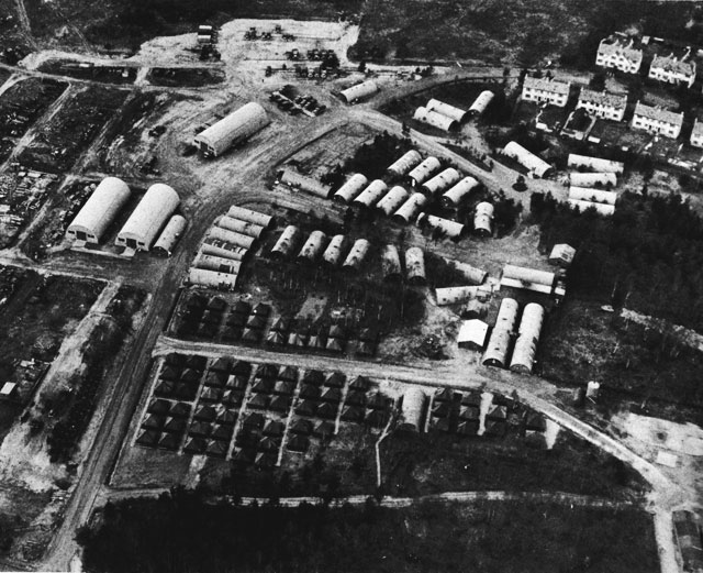
The plot thickens, the QM museum were very kind enough to take the time to reply..
"They look like WWI photographs. The building 600series with the tar paper walls and the sgt with the breeches, wrapleggings and M1913 Montana peak hat. The officers behind have WWI caps on. Yes, I am pretty sure they are WWI photos."
Also.. have come across this site:
www.ibiblio.org/hyperwar/USN/Building_Bases/bases-21.html
Which shows a US Naval Construction Battalion based at Heathfield in 1944, around a mile or so to the west. This site looks more like the location of the huts in the photographs with Candys chimneys to the east.
Attached files
This image is hidden for guests.
Replied by Pat_Pattle on topic Chudleigh Knighton US Fuel dump
I would have thought those scans were from WW1 judging by the uniforms and headgear.
The buildings also look very WW1 too.
The plot thickens, the QM museum were very kind enough to take the time to reply..
"They look like WWI photographs. The building 600series with the tar paper walls and the sgt with the breeches, wrapleggings and M1913 Montana peak hat. The officers behind have WWI caps on. Yes, I am pretty sure they are WWI photos."
Also.. have come across this site:
www.ibiblio.org/hyperwar/USN/Building_Bases/bases-21.html
Which shows a US Naval Construction Battalion based at Heathfield in 1944, around a mile or so to the west. This site looks more like the location of the huts in the photographs with Candys chimneys to the east.
Attached files
This image is hidden for guests.
Please log in or register to see it.
Please Log in or Create an account to join the conversation.
- Forum
- Open Forum
- Miscellaneous Research Topics
- General Airfield or 20th Century Military Architecture Discussion Topics
- Chudleigh Knighton US Fuel dump
Time to create page: 0.053 seconds