- Posts: 9794
- Thank you received: 652
- Forum
- Open Forum
- Miscellaneous Research Topics
- General Airfield or 20th Century Military Architecture Discussion Topics
- Surviving Range Control and Quadrant Towers
Surviving Range Control and Quadrant Towers
- REF
-
 Topic Author
- Offline
- Platinum Member
-

Less
More
16 Feb 2014 19:51 #1
by REF
Surviving Range Control and Quadrant Towers was created by REF
Hi folks;
Is there a list of surviving towers on bombing ranges anywhere? Ideally with an NGR or even better a GE kml file?
Thanks
Rich
Ellington (Huntingdonshire) = LOCATION
Grimston Warren 1 (Norfolk) = LOCATION
Grimston Warren 2 (Norfolk) = LOCATION
Rushford (Norfolk) = LOCATION
Titchwell (Norfolk) = LOCATION
Wainfleet (Lincolnshire) 1 = LOCATION
Wainfleet (Lincolnshire) 2 = LOCATION
Is there a list of surviving towers on bombing ranges anywhere? Ideally with an NGR or even better a GE kml file?
Thanks
Rich
Ellington (Huntingdonshire) = LOCATION
Grimston Warren 1 (Norfolk) = LOCATION
Grimston Warren 2 (Norfolk) = LOCATION
Rushford (Norfolk) = LOCATION
Titchwell (Norfolk) = LOCATION
Wainfleet (Lincolnshire) 1 = LOCATION
Wainfleet (Lincolnshire) 2 = LOCATION
Please Log in or Create an account to join the conversation.
- Peter Kirk
-

- Offline
- Moderator
-

Less
More
- Posts: 12446
- Thank you received: 1029
17 Feb 2014 01:01 #2
by Peter Kirk
No Amount Of Evidence Will Ever Persuade An Idiot (probably not Mark Twain)
Replied by Peter Kirk on topic Surviving Range Control and Quadrant Towers
I haven't got a separate list as it is embedded in my gazetteer of over 600 ranges! I can pull something together, if you promise to photograph them all, but it will take a while. I was actually thinking of putting them online as the bombing range list is now in need of an update. Having added a few "new" extant quadrant shelters a few have also been lost since I started so it would help to keep things up to date with changes.
No Amount Of Evidence Will Ever Persuade An Idiot (probably not Mark Twain)
Please Log in or Create an account to join the conversation.
- canberra
- Offline
- Platinum Member
-
Less
More
- Posts: 5639
- Thank you received: 122
17 Feb 2014 11:23 #3
by canberra
Replied by canberra on topic Surviving Range Control and Quadrant Towers
I believe the quadrant huts at Tain that I worked in 30 odd years ago are still in use.
Please Log in or Create an account to join the conversation.
- REF
-
Topic Author
- Offline
- Platinum Member
-
Less
More
- Posts: 9794
- Thank you received: 652
17 Feb 2014 17:27 #4
by REF
I'll plot them and do my best!!!!! It'll take a fair bit of time though!!
Replied by REF on topic Surviving Range Control and Quadrant Towers
if you promise to photograph them all
I'll plot them and do my best!!!!! It'll take a fair bit of time though!!
Please Log in or Create an account to join the conversation.
- Peter Kirk
-
- Offline
- Moderator
-
Less
More
- Posts: 12446
- Thank you received: 1029
17 Feb 2014 23:23 #5
by Peter Kirk
No Amount Of Evidence Will Ever Persuade An Idiot (probably not Mark Twain)
Replied by Peter Kirk on topic Surviving Range Control and Quadrant Towers
My quick scan comes up with 65, one of which was only added today. I'll work on the list over the coming days. I will use this as a basis for a fuller list of surviving range stuff. Hopefully some more information will result from this if only to say its now gone! At present my list doesn't include current ranges as most of the control/quadrant buildings are new and I haven't really looked at those as they are widely known.
No Amount Of Evidence Will Ever Persuade An Idiot (probably not Mark Twain)
Please Log in or Create an account to join the conversation.
- REF
-
Topic Author
- Offline
- Platinum Member
-
Less
More
- Posts: 9794
- Thank you received: 652
17 Feb 2014 23:42 #6
by REF
Replied by REF on topic Surviving Range Control and Quadrant Towers
Sounds great Peter, it will be a good place to start and we can add to it.
I'll get them plotted and see what else I can find.
Are there any others in Norfolk and Suffolk?
I'll get them plotted and see what else I can find.
Are there any others in Norfolk and Suffolk?
Please Log in or Create an account to join the conversation.
- Peter Kirk
-
- Offline
- Moderator
-
Less
More
- Posts: 12446
- Thank you received: 1029
18 Feb 2014 13:19 #7
by Peter Kirk
No Amount Of Evidence Will Ever Persuade An Idiot (probably not Mark Twain)
Replied by Peter Kirk on topic Surviving Range Control and Quadrant Towers
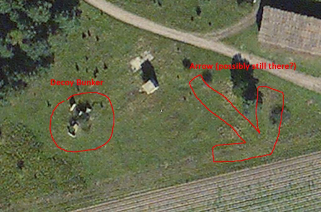
The only ones I have listed for Norfolk and Suffolk with QS remains are: Grimston Warren (those very tall concrete pillars), Rushford (I believe you have photographed that one) and Titchwell (Which I have photographed). I don't recall if you photographed the decoy bunker next to the quadrant shelter at Rushford and I also believes the concrete arrow remains to the east of the QS but covered in a thin layer of growth, obscuring it from the air. A LIDAR photo would show it if it is there but it is probably cheaper to go with a metal rod and map out the "thunks" via GPS 
Thunk = Technical term for the sound of metal rod hitting concrete (PS I just made that up but it might become common usage if I use it enough)
Thunk = Technical term for the sound of metal rod hitting concrete (PS I just made that up but it might become common usage if I use it enough)
No Amount Of Evidence Will Ever Persuade An Idiot (probably not Mark Twain)
Please Log in or Create an account to join the conversation.
- kebecker
-

- Offline
- Platinum Member
-
Less
More
- Posts: 2942
- Thank you received: 508
18 Feb 2014 15:30 #8
by kebecker
Ialways get confused with the name of this range, but its near Thetford so in the counties you want! I had access to this area during some survey work in the 90's Today it looks like there are some extensive pig farming going on so I suspect access permission may not be easy to get. Anyway the Quadrant tower was fairly intact then and looks as though it is still standing www.flashearth.com/?lat=52.397834&lon=0....&z=17.5&r=0&src="msl"
There were some other range gubbins which may also be extant, memory has got the better fo me in terms of the detail though
Replied by kebecker on topic Surviving Range Control and Quadrant Towers
The only ones I have listed for Norfolk and Suffolk with QS remains are: Grimston Warren (those very tall concrete pillars), Rushford (I believe you have photographed that one) and Titchwell (Which I have photographed). I don't recall if you photographed the decoy bunker next to the quadrant shelter at Rushford and I also believes the concrete arrow remains to the east of the QS but covered in a thin layer of growth, obscuring it from the air. A LIDAR photo would show it if it is there but it is probably cheaper to go with a metal rod and map out the "thunks" via GPS
Thunk = Technical term for the sound of metal rod hitting concrete (PS I just made that up but it might become common usage if I use it enough)
Ialways get confused with the name of this range, but its near Thetford so in the counties you want! I had access to this area during some survey work in the 90's Today it looks like there are some extensive pig farming going on so I suspect access permission may not be easy to get. Anyway the Quadrant tower was fairly intact then and looks as though it is still standing www.flashearth.com/?lat=52.397834&lon=0....&z=17.5&r=0&src="msl"
There were some other range gubbins which may also be extant, memory has got the better fo me in terms of the detail though
Please Log in or Create an account to join the conversation.
- Peter Kirk
-
- Offline
- Moderator
-
Less
More
- Posts: 12446
- Thank you received: 1029
18 Feb 2014 16:58 #9
by Peter Kirk
No Amount Of Evidence Will Ever Persuade An Idiot (probably not Mark Twain)
Replied by Peter Kirk on topic Surviving Range Control and Quadrant Towers
That range is Rushford and is often referred to, although never in official documents, as Snarehill after the WW1 aerodrome. Rushford was a well used and important range and was used by the 8th AF for a while. The attached extract from Flash Earth shows the QS (centre) and the two other features. I have outlined the arrow wider than reality so you can still see the vague outline on the grass. This could be either due to concrete removal and different soil infill or it is still there causing poorer growth.
PS the file name of the picture also refers to Canada's greatest export
Attached files
This image is hidden for guests.
PS the file name of the picture also refers to Canada's greatest export
Attached files
This image is hidden for guests.
Please log in or register to see it.
No Amount Of Evidence Will Ever Persuade An Idiot (probably not Mark Twain)
Please Log in or Create an account to join the conversation.
- kebecker
-
- Offline
- Platinum Member
-
Less
More
- Posts: 2942
- Thank you received: 508
18 Feb 2014 17:20 #10
by kebecker
Replied by kebecker on topic Surviving Range Control and Quadrant Towers
Thank for that. I was just looking at the 1st edition OS sheet and there is reference to a Volunteers Rifle Range which coincides with what I recall to be something like a stop butt in some trees at the northern end of the site. I had always assumed this was 40s range related, obvioulsy not.
Please Log in or Create an account to join the conversation.
- Forum
- Open Forum
- Miscellaneous Research Topics
- General Airfield or 20th Century Military Architecture Discussion Topics
- Surviving Range Control and Quadrant Towers
Time to create page: 0.059 seconds