- Posts: 94
- Thank you received: 9
Structure in Field
- Gone
-
 Topic Author
- Offline
- Banned
-

Less
More
31 Oct 2015 14:35 #1
by Gone
Structure in Field was created by Gone
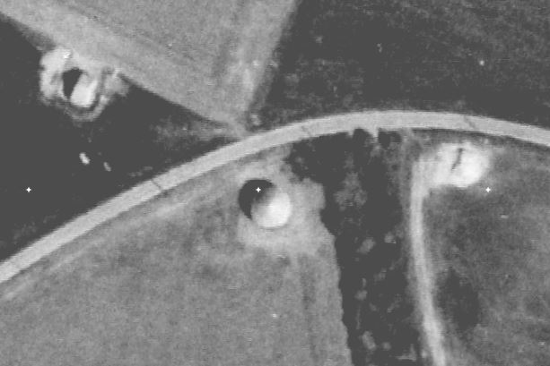
While browsing Google Earth I noticed some structures in a field between Dungate and Lynsted in Kent - NGR TQ926594. They may be of no significance but just look out of place somehow. Is anything know in the area?
A post war an AA site was built in the adjacent field but does not seem to have any connection.
This image is hidden for guests.
A post war an AA site was built in the adjacent field but does not seem to have any connection.
This image is hidden for guests.
Please log in or register to see it.
Please Log in or Create an account to join the conversation.
- PETERTHEEATER
-

- Offline
- Platinum Member
-

Less
More
- Posts: 10905
- Thank you received: 772
01 Nov 2015 10:35 #2
by PETERTHEEATER
Replied by PETERTHEEATER on topic Structure in Field
Not my line but the layout appears to be of a transmitter with aerial masts although there are no shadows of these.
Had a quick Google and found this:
www.bletchleyparkresearch.co.uk/research...kingsdown-y-station/
Had a quick Google and found this:
www.bletchleyparkresearch.co.uk/research...kingsdown-y-station/
Please Log in or Create an account to join the conversation.
- mbriscoe
-

- Offline
- Moderator
-

01 Nov 2015 11:16 #3
by mbriscoe
Replied by mbriscoe on topic Structure in Field
Kent HER have the
1946 images
online, so can see the wartime radio station.
The BBC had their frequency checking site at Kingsdown but sure it will have closed now.
Correction, Tatsfield was the main frequency checking site, getting confused with Kingswood Warren which was Research Department.
The BBC had their frequency checking site at Kingsdown but sure it will have closed now.
Correction, Tatsfield was the main frequency checking site, getting confused with Kingswood Warren which was Research Department.
Please Log in or Create an account to join the conversation.
- carnaby
-

- Offline
- Platinum Member
-
Less
More
- Posts: 5026
- Thank you received: 440
01 Nov 2015 13:40 #4
by carnaby
Plan A is always more effective when the problem you are working on understands that Plan B will involve the use of dynamite
Replied by carnaby on topic Structure in Field
These Kingsdowns are a pain in the ****.
The 'Y' service used two Kingsdowns - one near Deal and the other at West Kingsdown, but post #1 refers to yet another Kingsdown near Sittingbourne which is more than 20 miles distant from the first two.
The 'Y' service used two Kingsdowns - one near Deal and the other at West Kingsdown, but post #1 refers to yet another Kingsdown near Sittingbourne which is more than 20 miles distant from the first two.
Plan A is always more effective when the problem you are working on understands that Plan B will involve the use of dynamite
Please Log in or Create an account to join the conversation.
- Peter Kirk
-

- Offline
- Moderator
-
Less
More
- Posts: 12446
- Thank you received: 1029
01 Nov 2015 19:22 #5
by Peter Kirk
No Amount Of Evidence Will Ever Persuade An Idiot (probably not Mark Twain)
Replied by Peter Kirk on topic Structure in Field
Lucky it was based at one of the Bottoms 
No Amount Of Evidence Will Ever Persuade An Idiot (probably not Mark Twain)
Please Log in or Create an account to join the conversation.
- Gone
-
Topic Author
- Offline
- Banned
-
Less
More
- Posts: 94
- Thank you received: 9
04 Nov 2015 19:27 #6
by Gone
Replied by Gone on topic Structure in Field
Thanks for the replies, a friend has suggested it could be a direction finding station and on searching it came across this www.flashearth.com/?lat=52.391857&lon=-0...&z=17.8&r=0&src="ggl" which is said to be a D/F station at Warboys.
I can see similarities in the structures at the two sites but would appreciate your opinions as i know nothing about the subject.
I can see similarities in the structures at the two sites but would appreciate your opinions as i know nothing about the subject.
Please Log in or Create an account to join the conversation.
- carnaby
-
- Offline
- Platinum Member
-
Less
More
- Posts: 5026
- Thank you received: 440
04 Nov 2015 20:18 #7
by carnaby
That site at Warboys is still a bit of a mystery and has been described on other websites as:
I think it was probably all of the last three, probably not a D/F station (It's too 'heavy duty'). I suspect it has almost nothing in common with our 'unknown structure'.
Plan A is always more effective when the problem you are working on understands that Plan B will involve the use of dynamite
Replied by carnaby on topic Structure in Field
... a D/F station at Warboys.
That site at Warboys is still a bit of a mystery and has been described on other websites as:
Direction Finding Station
No.3 Group Transmitting Station (WWII)
Cold war Transmitter Station
W/T Station for RAF Wyton. LINK
No.3 Group Transmitting Station (WWII)
Cold war Transmitter Station
W/T Station for RAF Wyton. LINK
I think it was probably all of the last three, probably not a D/F station (It's too 'heavy duty'). I suspect it has almost nothing in common with our 'unknown structure'.
Plan A is always more effective when the problem you are working on understands that Plan B will involve the use of dynamite
Please Log in or Create an account to join the conversation.
- Gone
-
Topic Author
- Offline
- Banned
-
Less
More
- Posts: 94
- Thank you received: 9
05 Nov 2015 10:08 #8
by Gone
Thanks. In view of your comments I enlarged vies of both and I can now see that there is no similarity. Enlarged the main structure looks even odder:
This image is hidden for guests.
Replied by Gone on topic Structure in Field
That site at Warboys is still a bit of a mystery and has been described on other websites as:
Direction Finding Station
No.3 Group Transmitting Station (WWII)
Cold war Transmitter Station
W/T Station for RAF Wyton. LINK
I think it was probably all of the last three, probably not a D/F station (It's too 'heavy duty'). I suspect it has almost nothing in common with our 'unknown structure'.
Thanks. In view of your comments I enlarged vies of both and I can now see that there is no similarity. Enlarged the main structure looks even odder:
This image is hidden for guests.
Please log in or register to see it.
Please Log in or Create an account to join the conversation.
- PETERTHEEATER
-
- Offline
- Platinum Member
-
Less
More
- Posts: 10905
- Thank you received: 772
05 Nov 2015 12:04 #9
by PETERTHEEATER
Replied by PETERTHEEATER on topic Structure in Field
But, you agree it appears to be a hut (Nissen) surrounded by a brick or concrete blast wall with two pedestrian entrances through the wall north and south? Could also be earth traversed. The external 'cube' could be a generator room.
Please Log in or Create an account to join the conversation.
- mbriscoe
-
- Offline
- Moderator
-
05 Nov 2015 13:51 #10
by mbriscoe
Slightly clearer on the HER.
This image is hidden for guests.
Is that a VHF DF to the NE?
Another one perhaps?
This image is hidden for guests.
And what about these?
This image is hidden for guests.
Replied by mbriscoe on topic Structure in Field
But, you agree it appears to be a hut (Nissen) surrounded by a brick or concrete blast wall with two pedestrian entrances through the wall north and south? Could also be earth traversed. The external 'cube' could be a generator room.
Slightly clearer on the HER.
This image is hidden for guests.
Please log in or register to see it.
Is that a VHF DF to the NE?
Another one perhaps?
This image is hidden for guests.
Please log in or register to see it.
And what about these?
This image is hidden for guests.
Please log in or register to see it.
Please Log in or Create an account to join the conversation.
Time to create page: 0.051 seconds