- Posts: 19
- Thank you received: 0
- Forum
- Open Forum
- Miscellaneous Research Topics
- General Airfield or 20th Century Military Architecture Discussion Topics
- RAF 'Y' Stations etc. Discussion Thread
RAF 'Y' Stations etc. Discussion Thread
- Stan Ames
- Offline
- New Member
-

Less
More
04 Oct 2011 15:33 #61
by Stan Ames
Replied by Stan Ames on topic RAF 'Y' Stations etc.
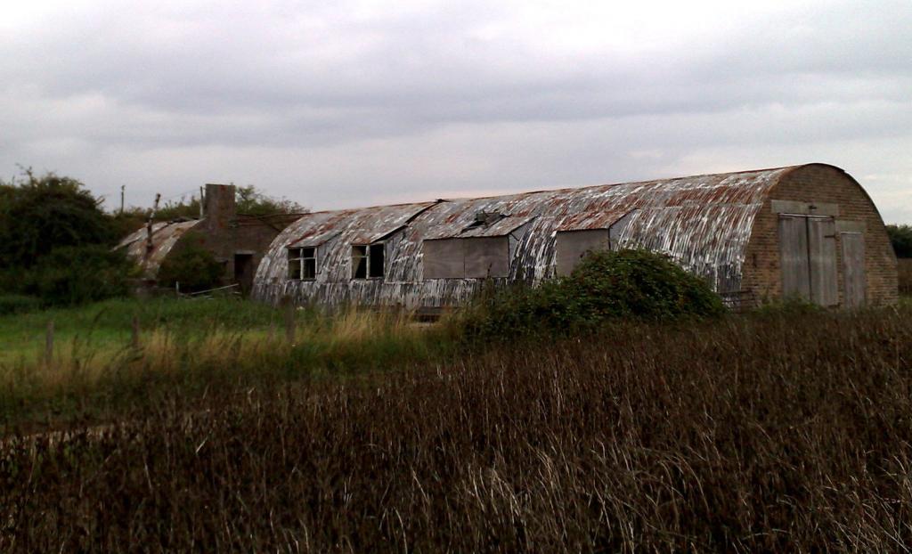
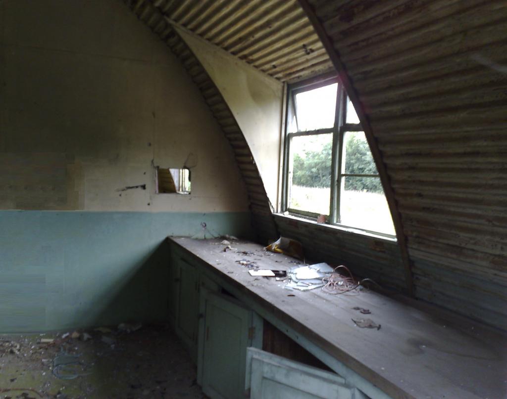
Here is a photo of what the Ford End control rooms look like now. Inside they are very much the same as they were left in the 1970s.
This image is hidden for guests.
This image is hidden for guests.
Stan
This image is hidden for guests.
Please log in or register to see it.
This image is hidden for guests.
Please log in or register to see it.
Stan
Please Log in or Create an account to join the conversation.
- HF Dave
-

- Offline
- Senior Member
-

Less
More
- Posts: 365
- Thank you received: 30
03 Nov 2011 21:10 #62
by HF Dave
Replied by HF Dave on topic RAF 'Y' Stations etc.
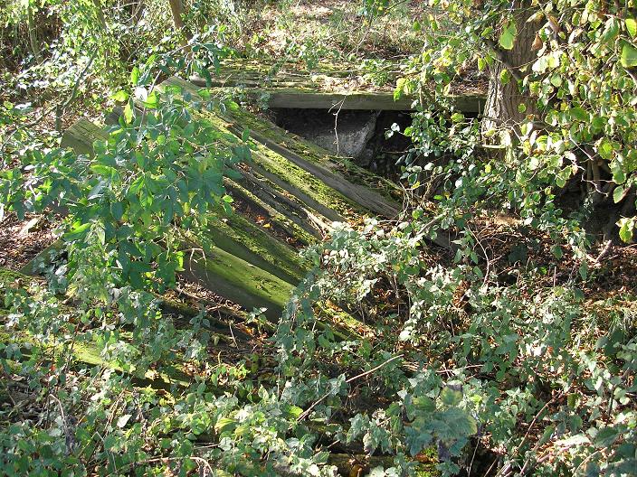
You can also still see remains of the concrete tracks laid between the five DF sites and the command post. For example there is a broken bridge crossing a ditch between the 4th and 5th site (counting from 1 to 5 west to east):
This image is hidden for guests.
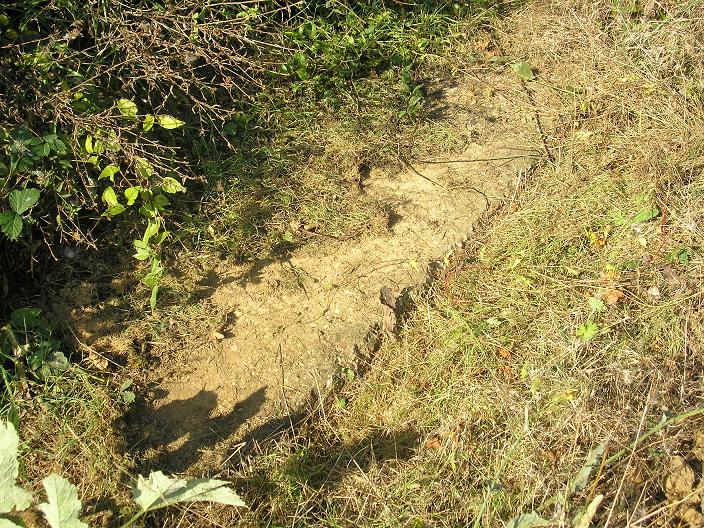
And here is the track visible at the edge of the field north of the command post:
This image is hidden for guests.
From a quick glance at the OS maps, site 5 (most westerly) seems to have been removed in the 1950s (was this the spare one in the original configuration), and by the 1970s only site 3 seems to be left. I know that Marconis did some installation tests here in 1944.
This image is hidden for guests.
Please log in or register to see it.
And here is the track visible at the edge of the field north of the command post:
This image is hidden for guests.
Please log in or register to see it.
From a quick glance at the OS maps, site 5 (most westerly) seems to have been removed in the 1950s (was this the spare one in the original configuration), and by the 1970s only site 3 seems to be left. I know that Marconis did some installation tests here in 1944.
Please Log in or Create an account to join the conversation.
- Stan Ames
- Offline
- New Member
-
Less
More
- Posts: 19
- Thank you received: 0
04 Nov 2011 16:43 #63
by Stan Ames
Replied by Stan Ames on topic RAF 'Y' Stations etc.
HF Dave
I didn't realise there were any of the tracks remaining at Ford End, a nice piece of investigation. I remember speaking to the Son of the farmer who went with his Dad to deliver milk to all the stations in his car, so there must have been tracks for vehicles to all of them. There was a note in the archives about there already being a station at Ford End which prompted them to use it as the location of the first group of 5 stations. Marconi installed the group and I have a copy of their report although its a huge document filled with loads of test data. The photo below shows the title page. If anyone is interested I could put the report on the net for people to download.
[IMG]/community/88009=6513-ford end title.jpg[/img]
I didn't realise there were any of the tracks remaining at Ford End, a nice piece of investigation. I remember speaking to the Son of the farmer who went with his Dad to deliver milk to all the stations in his car, so there must have been tracks for vehicles to all of them. There was a note in the archives about there already being a station at Ford End which prompted them to use it as the location of the first group of 5 stations. Marconi installed the group and I have a copy of their report although its a huge document filled with loads of test data. The photo below shows the title page. If anyone is interested I could put the report on the net for people to download.
[IMG]/community/88009=6513-ford end title.jpg[/img]
Please Log in or Create an account to join the conversation.
- Robyn Griffiths
- Offline
- New Member
-
Less
More
- Posts: 8
- Thank you received: 0
05 Nov 2011 16:08 #64
by Robyn Griffiths
Replied by Robyn Griffiths on topic RAF 'Y' Stations etc.
This afternoon I walked to the two of the locations of RAF Kingsdown Y Station
This is Mizpah (meaning Watchtower) on Fawkham Road, West Kingsdown as it is today. The house was the office part of the station and a disused toy factory behind was the operations area. I can't get into to see that site yet. I hope to on Monday
[IMG]/community/88104=6522-RAF Kingsdown Mizpah location small.jpg[/img]
The Station then moved about 3/4 of a mile up the road to Hollywood Manor on School Lane. Again I can't get into the Manor without an invite and the photo's are taken from the road.
[IMG]/community/88104=6519-RAF Kingsdown Hollywood Manor location (1) small.jpg[/img]
[IMG]/community/88104=6520-RAF Kingsdown Hollywood Manor location (2) small.jpg[/img]
[IMG]/community/88104=6521-RAF Kingsdown Hollywood Manor location (3) small.jpg[/img]
I should be able to get photos as and when I get invited into the locations
This is Mizpah (meaning Watchtower) on Fawkham Road, West Kingsdown as it is today. The house was the office part of the station and a disused toy factory behind was the operations area. I can't get into to see that site yet. I hope to on Monday
[IMG]/community/88104=6522-RAF Kingsdown Mizpah location small.jpg[/img]
The Station then moved about 3/4 of a mile up the road to Hollywood Manor on School Lane. Again I can't get into the Manor without an invite and the photo's are taken from the road.
[IMG]/community/88104=6519-RAF Kingsdown Hollywood Manor location (1) small.jpg[/img]
[IMG]/community/88104=6520-RAF Kingsdown Hollywood Manor location (2) small.jpg[/img]
[IMG]/community/88104=6521-RAF Kingsdown Hollywood Manor location (3) small.jpg[/img]
I should be able to get photos as and when I get invited into the locations
Please Log in or Create an account to join the conversation.
- Stan Ames
- Offline
- New Member
-
Less
More
- Posts: 19
- Thank you received: 0
01 Dec 2011 15:02 #65
by Stan Ames
Replied by Stan Ames on topic RAF 'Y' Stations etc.
For some time I have been confused about Y station(s) in Dunstable. If you check Google maps at the junction of Tring Rd running east from Dunstable and Leighton Rd -(google maps/earth 51.849114,-0.582919). You will see a "+" shaped building in a field surrounded by marks suggesting earlier aerials. I thought this was a Meteo Y station run by the Met Office in WW2 and it was stated as such on several sites. But it was in fact an RAF, high power transmitting station built in WW2 and vacated in the 1990s.
The Meteo Y station was actually near Drovers Way on the northern ege of Dunstable near the A5 -Google Earth 1945 - (51.885339,-0.537944). I finally tracked down this elusive station with the help of David White at Bletchley Park and Martin Briscoe of Fort William. A dim image can be seen on 1945 Google earth images, but you can see a cleaned up version here -
dl.dropbox.com/u/33983550/WW2/DunstableMet.jpg
I hope to find a clearer image at Beds. archives.
Stan
The Meteo Y station was actually near Drovers Way on the northern ege of Dunstable near the A5 -Google Earth 1945 - (51.885339,-0.537944). I finally tracked down this elusive station with the help of David White at Bletchley Park and Martin Briscoe of Fort William. A dim image can be seen on 1945 Google earth images, but you can see a cleaned up version here -
dl.dropbox.com/u/33983550/WW2/DunstableMet.jpg
I hope to find a clearer image at Beds. archives.
Stan
Please Log in or Create an account to join the conversation.
- ted angus
- Offline
- Platinum Member
-

Less
More
- Posts: 1643
- Thank you received: 51
01 Dec 2011 16:59 #66
by ted angus
Replied by ted angus on topic RAF 'Y' Stations etc.
Hi Stan did you see my post No 34 on this thread. People who served at The Met Y station have stated on the BBC site that the entrance was off Worthington Road. It is in the area where Worthington Rd joins Drovers way. The Co-ord I have from GE : entrance is 51.530574 0.320962. The area you show I make 51.530979. 0.322677. there is a hutted camp ? at 51.525336 0.320425
TED
TED
Please Log in or Create an account to join the conversation.
- Jenna
- Offline
- Senior Member
-
Less
More
- Posts: 371
- Thank you received: 1
01 Dec 2011 22:55 #67
by Jenna
Replied by Jenna on topic RAF 'Y' Stations etc.
The entrance to the Met Y at Dunstable was indeed on Worthington Rd, as that time drovers way never existed.. the entrance was just before the last semi before Drovers way (this semi being built with the Drovers Way construction).. the GE cords are 51.884857°, -0.536329°.
The actual site is the block now accessed by Weatherby Road.... 51.887413°,-0.540669°
This information came to me via Brian Audric who is a bit of an expert on the MO/IDA Dunstable. I have a copy of his editorial to the RMS back in 2000 here if its any help.
www.raidxtreme.eu/webpics/rms2000.pdf
I compile a list of WW2 sites in the Bedfordshire, Buckinghamshire and Hertfordshire...
maps.google.co.uk/maps/ms?msa=0&msid=205...768773,1.674042&z=10
Ted, I remember reading you knew Sundon Park well at one time.... I have come across a site that you may able to help with. According to some paperwork there was a 'training centre' at the the end of Whitefield Avenue during WW2 but I can find no further information can you help? It became the Heron Business Park under the ownership of a friend (and old boss) until recently when it was redeveloped as housing.
FE location is here www.flashearth.com/?lat=51.91489&lon=-0....&z=18.5&r=0&src="msl"
The actual site is the block now accessed by Weatherby Road.... 51.887413°,-0.540669°
This information came to me via Brian Audric who is a bit of an expert on the MO/IDA Dunstable. I have a copy of his editorial to the RMS back in 2000 here if its any help.
www.raidxtreme.eu/webpics/rms2000.pdf
I compile a list of WW2 sites in the Bedfordshire, Buckinghamshire and Hertfordshire...
maps.google.co.uk/maps/ms?msa=0&msid=205...768773,1.674042&z=10
Ted, I remember reading you knew Sundon Park well at one time.... I have come across a site that you may able to help with. According to some paperwork there was a 'training centre' at the the end of Whitefield Avenue during WW2 but I can find no further information can you help? It became the Heron Business Park under the ownership of a friend (and old boss) until recently when it was redeveloped as housing.
FE location is here www.flashearth.com/?lat=51.91489&lon=-0....&z=18.5&r=0&src="msl"
Please Log in or Create an account to join the conversation.
- ted angus
- Offline
- Platinum Member
-
Less
More
- Posts: 1643
- Thank you received: 51
01 Dec 2011 23:49 #68
by ted angus
Replied by ted angus on topic RAF 'Y' Stations etc.
Jenna firstly Sundon Park. My parents moved to third ave in 1940 from London, Dad started then at Commers Mum was in the Ministry of Labour & national Service. On Sundon Park road not far from the turning into Whitefield Ave was the home of Dr O Donnell the surgery was also in his house on the left side as viewed on your flashearth about opposite the S in the road title. . just into Whitefield there was a shop in the front room of a house 2 or 3 houses down on the right, the guy was called Coyer or similar. Coyer & my Dad were the wardens for ARP for Sundon Park, there post was in the shop as it had a phone. . I was told Dr O Donnell's house was hit by incendaries one night, My Dad always reckoned they were after either SKEFCO just a mile further north or the training centre- I was never told what the training centre did ???
OK question, I just looked at the Met Y again on GE and then on Flashearth, Why when I look up do I get a totally different westerly everyone is quoteing 0.54etc mine reads 0.32etc on both GE and flashearth. please see attached.
regards TED
Attached files [IMG]/community/90479=6943-Site entrance.jpg[/img]
OK question, I just looked at the Met Y again on GE and then on Flashearth, Why when I look up do I get a totally different westerly everyone is quoteing 0.54etc mine reads 0.32etc on both GE and flashearth. please see attached.
regards TED
Attached files [IMG]/community/90479=6943-Site entrance.jpg[/img]
Please Log in or Create an account to join the conversation.
- Jenna
- Offline
- Senior Member
-
Less
More
- Posts: 371
- Thank you received: 1
02 Dec 2011 09:46 #69
by Jenna
Replied by Jenna on topic RAF 'Y' Stations etc.
Thanks Ted, I did find information on a Mr Cheek ARP Warden and there is a mention of another at 18 Whitefield Road (BLARS archive, 9 Oct 1940) but no name. I have wondered if the training centre was Home Guard?.... I'll go back into the records to see if I missed any thing.
The mismatch over co ords is your set to Deg-Min-Sec, I use decimal Degrees as the default as its easier to work with.... with DMS you will find the error will increase further from 0,0 you move hence the problem.
The mismatch over co ords is your set to Deg-Min-Sec, I use decimal Degrees as the default as its easier to work with.... with DMS you will find the error will increase further from 0,0 you move hence the problem.
Please Log in or Create an account to join the conversation.
- ted angus
- Offline
- Platinum Member
-
Less
More
- Posts: 1643
- Thank you received: 51
02 Dec 2011 10:13 #70
by ted angus
Replied by ted angus on topic RAF 'Y' Stations etc.
Morning Jenna, my parents were in Sundon Park before the december 40 blitz on London from stories they told me, but possibly only just. . I have tried to pick up the door numbers on Whitefield without success. Coyer was in one of the first 3 semi blocks on the right as you enter from sundon park road. and he was in a right hand house of which ever one it was.
As a kid we got over into the training centre many times but my memory tells me they were mostly brick buildings flat concrete roofs but not what I would associate with residential accom. but its 50 + years ago now.
re GE co-ords yes that is the problem I am still in old money not decimal.
regards TED
As a kid we got over into the training centre many times but my memory tells me they were mostly brick buildings flat concrete roofs but not what I would associate with residential accom. but its 50 + years ago now.
re GE co-ords yes that is the problem I am still in old money not decimal.
regards TED
Please Log in or Create an account to join the conversation.
- Forum
- Open Forum
- Miscellaneous Research Topics
- General Airfield or 20th Century Military Architecture Discussion Topics
- RAF 'Y' Stations etc. Discussion Thread
Time to create page: 0.052 seconds

![[IMG]/community/88009=6513-ford end title.jpg[/img]](/community/88009=6513-ford%20end%20title.jpg)
![[IMG]/community/88104=6522-RAF Kingsdown Mizpah location small.jpg[/img]](/community/88104=6522-RAF%20Kingsdown%20Mizpah%20location%20small.jpg)
![[IMG]/community/88104=6519-RAF Kingsdown Hollywood Manor location (1) small.jpg[/img]](/community/88104=6519-RAF%20Kingsdown%20Hollywood%20Manor%20location%20(1)%20small.jpg)
![[IMG]/community/88104=6520-RAF Kingsdown Hollywood Manor location (2) small.jpg[/img]](/community/88104=6520-RAF%20Kingsdown%20Hollywood%20Manor%20location%20(2)%20small.jpg)
![[IMG]/community/88104=6521-RAF Kingsdown Hollywood Manor location (3) small.jpg[/img]](/community/88104=6521-RAF%20Kingsdown%20Hollywood%20Manor%20location%20(3)%20small.jpg)

![[IMG]/community/90479=6943-Site entrance.jpg[/img]](/community/90479=6943-Site%20entrance.jpg)