- Forum
- Open Forum
- Miscellaneous Research Topics
- General Airfield or 20th Century Military Architecture Discussion Topics
- RAF 'Y' Stations etc. Discussion Thread
RAF 'Y' Stations etc. Discussion Thread
- mbriscoe
-

- Offline
- Moderator
-

Less
More
14 May 2013 22:55 #81
by mbriscoe
Replied by mbriscoe on topic RAF 'Y' Stations etc.
Please Log in or Create an account to join the conversation.
- mbriscoe
-
- Offline
- Moderator
-
14 May 2013 23:56 #82
by mbriscoe
Replied by mbriscoe on topic RAF 'Y' Stations etc.
Pictures of
Magask
Please Log in or Create an account to join the conversation.
- mbriscoe
-
- Offline
- Moderator
-
29 May 2013 09:20 #83
by mbriscoe
Sheigra is now on Canmore, I was trying to remember where I had seen a reference to a PO station there and found it was me that had originally found the reference in RAF Signals 1939-1945
GPO Transmitters
At the outbreak of war, the following GPO medium or long wave WT transmissions were put under the control of Fighter Command –
Leafield, Rugby, Portishead, Cullercoats, Humber, Lands End. Niton, North Foreland, Portpatrick, Caernarvon, Ongar, Parkeston Quay, Stonehaven, Seaforth, Wick, Sheigra, Callon Head, Tiree, Sanday and North Ronaldsway.
This was a way of closing them down rather than taking over the transmitters.
Replied by mbriscoe on topic RAF 'Y' Stations etc.
The RN DF station at Sheigra .
Sheigra is now on Canmore, I was trying to remember where I had seen a reference to a PO station there and found it was me that had originally found the reference in RAF Signals 1939-1945
GPO Transmitters
At the outbreak of war, the following GPO medium or long wave WT transmissions were put under the control of Fighter Command –
Leafield, Rugby, Portishead, Cullercoats, Humber, Lands End. Niton, North Foreland, Portpatrick, Caernarvon, Ongar, Parkeston Quay, Stonehaven, Seaforth, Wick, Sheigra, Callon Head, Tiree, Sanday and North Ronaldsway.
This was a way of closing them down rather than taking over the transmitters.
Please Log in or Create an account to join the conversation.
- mbriscoe
-
- Offline
- Moderator
-
29 May 2013 21:20 #84
by mbriscoe
This article was pointed out to me
Published: 18/12/2008 00:00 - Updated: 29/11/2011 16:45
25 Years Ago
Blairmore is same area as Sheigra.
I wonder if locals had heard comments about the DF station tracking or locating ships, U-Boats or aircraft and presuming that it was radar?
MB
Replied by mbriscoe on topic RAF 'Y' Stations etc.
The RN DF station at Sheigra .
I also found Magask, pictures tomorrow hopefully.
This article was pointed out to me
Published: 18/12/2008 00:00 - Updated: 29/11/2011 16:45
25 Years Ago
Blairmore is same area as Sheigra.
I wonder if locals had heard comments about the DF station tracking or locating ships, U-Boats or aircraft and presuming that it was radar?
MB
Please Log in or Create an account to join the conversation.
- PETERTHEEATER
-

- Offline
- Platinum Member
-

Less
More
- Posts: 10905
- Thank you received: 772
12 Jun 2013 09:04 #85
by PETERTHEEATER
Replied by PETERTHEEATER on topic RAF 'Y' Stations etc.
I'm not sure if this link has been posted before.
Lyme Regis 'Y' Station:
www.monktonwyldcourt.co.uk/About_the_Cou...utHistory%20copy.pdf
Lyme Regis 'Y' Station:
www.monktonwyldcourt.co.uk/About_the_Cou...utHistory%20copy.pdf
Please Log in or Create an account to join the conversation.
- fixit
- Offline
- New Member
-

Less
More
- Posts: 2
- Thank you received: 0
14 Jul 2013 19:19 #86
by fixit
Replied by fixit on topic RAF 'Y' Stations etc.
Ive been researching the HFDF station a mile or so from ibsley ww2 airfield in the new forest. Very little is left now.
This one doesn't seem to appear in any lists so I'm not sure which organisation operated here- its very isolated.
According to the national mapping this station also had a long dipole aerial on posts(about 1km in length) aligned to intercept from Germany.
Anyone else come across this configuration? The shape is something like a Y from above but with another central arm .
Thanks to anyone responding.
fixit
This one doesn't seem to appear in any lists so I'm not sure which organisation operated here- its very isolated.
According to the national mapping this station also had a long dipole aerial on posts(about 1km in length) aligned to intercept from Germany.
Anyone else come across this configuration? The shape is something like a Y from above but with another central arm .
Thanks to anyone responding.
fixit
Please Log in or Create an account to join the conversation.
- Stan Ames
- Offline
- New Member
-
Less
More
- Posts: 19
- Thank you received: 0
09 Oct 2013 16:43 #87
by Stan Ames
Replied by Stan Ames on topic RAF 'Y' Stations etc.
Hi Fixit
Your station and its aerials sound interesting. HFDF stations had four 10m vertical aerials closely spaced around a small operator hut, but the other aerial you describe could be a rhombic aerial which was used widely in interception. The rhombic aerials were highly directional and took the form of a diamond shape and could be quite large depending on the frequency. The 1km long aerial may have been a "Beverage" antenna, this too was directional and could have been for interception. I have lists of Intelligence gathering stations from National Archives but I don't recognise the location. Are there any other local towns or village names it might have been recorded under? Alternatively, it may not be on any of the WW2 intelligence lists because many airfields had HF and MF DF stations purely for navigational purposes.
Regards
Stan
Your station and its aerials sound interesting. HFDF stations had four 10m vertical aerials closely spaced around a small operator hut, but the other aerial you describe could be a rhombic aerial which was used widely in interception. The rhombic aerials were highly directional and took the form of a diamond shape and could be quite large depending on the frequency. The 1km long aerial may have been a "Beverage" antenna, this too was directional and could have been for interception. I have lists of Intelligence gathering stations from National Archives but I don't recognise the location. Are there any other local towns or village names it might have been recorded under? Alternatively, it may not be on any of the WW2 intelligence lists because many airfields had HF and MF DF stations purely for navigational purposes.
Regards
Stan
Please Log in or Create an account to join the conversation.
- outkast
- Offline
- Senior Member
-

Less
More
- Posts: 140
- Thank you received: 0
12 Oct 2013 09:09 #88
by outkast
Was there a y station in kenley?
Replied by outkast on topic RAF 'Y' Stations etc.
Was there a y station in kenley?
Please Log in or Create an account to join the conversation.
- HF Dave
-

- Offline
- Senior Member
-
Less
More
- Posts: 365
- Thank you received: 30
13 Oct 2013 16:11 #89
by HF Dave
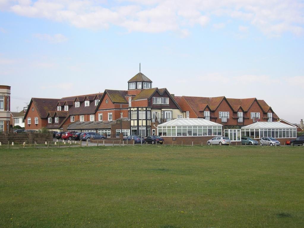
Fayreness Hotel earlier this year:
This image is hidden for guests.
The central portion (including the tower) is original, the wings being later additions.
As one might expect, there was a lot of activity in this area during WWII. Just outside the hotel on the greensward there was a whole cluster of features - including a circular gun pit, an rectangular earthwork, a square structure and an L-shaped trench. Perhaps these are associated with the listening station, although the central tower of the hotel wouldn't have made a bad place for a small aerial.
There was also a petroleum warfare site on the beach below, and Neptune's Tower (an 18th century folly built by Lord Holland) to the east was used as some kind of look-out. And the tunnels in the chalk cliffs may have been defended.
RAF Foreness was just a short distance to the NW.
Replied by HF Dave on topic RAF 'Y' Stations etc.
I have just looked up Fayreness and the address was :- Fayreness Hotel,Kingsgate, Nr Broadstairs. the lat long was 51deg 5 1/4 min North, 1deg 24 min East. not very accurate bit it will give a general area. The hotel was probably where the crew were billeted.
Stan
Fayreness Hotel earlier this year:
This image is hidden for guests.
Please log in or register to see it.
The central portion (including the tower) is original, the wings being later additions.
As one might expect, there was a lot of activity in this area during WWII. Just outside the hotel on the greensward there was a whole cluster of features - including a circular gun pit, an rectangular earthwork, a square structure and an L-shaped trench. Perhaps these are associated with the listening station, although the central tower of the hotel wouldn't have made a bad place for a small aerial.
There was also a petroleum warfare site on the beach below, and Neptune's Tower (an 18th century folly built by Lord Holland) to the east was used as some kind of look-out. And the tunnels in the chalk cliffs may have been defended.
RAF Foreness was just a short distance to the NW.
Please Log in or Create an account to join the conversation.
- HF Dave
-
- Offline
- Senior Member
-
Less
More
- Posts: 365
- Thank you received: 30
13 Oct 2013 16:23 #90
by HF Dave
Replied by HF Dave on topic RAF 'Y' Stations etc.
A couple of WWII vintage photos relating to the Fayreness Y-station:
www.australiansatwar.gov.au/stories/stories_war=W2_id=62.html
What's that on top of the cliffs? Simply fencing, or aerials?
www.australiansatwar.gov.au/stories/stories_war=W2_id=62.html
What's that on top of the cliffs? Simply fencing, or aerials?
Please Log in or Create an account to join the conversation.
- Forum
- Open Forum
- Miscellaneous Research Topics
- General Airfield or 20th Century Military Architecture Discussion Topics
- RAF 'Y' Stations etc. Discussion Thread
Time to create page: 0.084 seconds