- Posts: 10905
- Thank you received: 772
- Forum
- Open Forum
- Miscellaneous Research Topics
- Research Material, Websites and Useful Links
- Google Earth thread!
Google Earth thread!
- PETERTHEEATER
-

- Offline
- Platinum Member
-

Less
More
11 Sep 2010 03:57 #41
by PETERTHEEATER
Replied by PETERTHEEATER on topic Google Earth thread!
Hal, I don't know whether to laugh or cry. Thanks for the tip but it has great potential for diverting me from my core subjects!!
I think that Google will increase the cover eventually.
Just tried your Deethorpe example but get only a green carpet, what should be shown?
Belay that last pipe! Just tried Molesworth, I like it and so will PNK and many other AiXers! The 1945 imagery is not quite synchronised to the Layers (e.g. Roads) so your existing Placemarks may appear out of location. But, very useful.
I think that Google will increase the cover eventually.
Just tried your Deethorpe example but get only a green carpet, what should be shown?
Belay that last pipe! Just tried Molesworth, I like it and so will PNK and many other AiXers! The 1945 imagery is not quite synchronised to the Layers (e.g. Roads) so your existing Placemarks may appear out of location. But, very useful.
Please Log in or Create an account to join the conversation.
- PETERTHEEATER
-
- Offline
- Platinum Member
-
Less
More
- Posts: 10905
- Thank you received: 772
11 Sep 2010 04:34 #42
by PETERTHEEATER
Replied by PETERTHEEATER on topic Google Earth thread!
Just looked at Finmere in the 1945 imagery and you would be hard pushed to see an airfield!! I though that the imagery was wrong but found a pair of buildings in the right place. There is more visible evidence in the current view. What's going on here? Censorship?
Keevil is another site which is invisible.
Keevil is another site which is invisible.
Please Log in or Create an account to join the conversation.
- Peter Kirk
-

- Offline
- Moderator
-

Less
More
- Posts: 12446
- Thank you received: 1029
11 Sep 2010 08:20 #43
by Peter Kirk
No Amount Of Evidence Will Ever Persuade An Idiot (probably not Mark Twain)
Replied by Peter Kirk on topic Google Earth thread!
Generally if the photos have town and village names printed on them they are OS published versions and normally censored, mainly airfields but the odd mysterious cloud usually hides a post-war AA site. The ones that do show airfields tend to be RAF originals. Some exceptions will be where original un censored stock has been fitted in. A lot of the sections match those on Getmapping.com and UKaerialphotos.com but not entirely. I suspect more will follow but you have to wonder why you would want to pay for the same images on the commercial sites as the quality of the purchsed product is similar to that on GE.
There are some oddities and one that springs to mind is Rougham (Bury St Edmund) which is shown under contruction!
There are some oddities and one that springs to mind is Rougham (Bury St Edmund) which is shown under contruction!
No Amount Of Evidence Will Ever Persuade An Idiot (probably not Mark Twain)
Please Log in or Create an account to join the conversation.
- daveg4otu
-

- Offline
- Platinum Member
-
11 Sep 2010 08:31 #44
by daveg4otu
See my Hampshire,Dorset,Devon,IOW Airfields sites..
www.hampshireairfields.co.uk/
Replied by daveg4otu on topic Google Earth thread!
Yes there seems to be censorship in some places.
Not a lot available for my part of the UK - but the area around Blanford & Wimborne is covered - but Tarrant Rushton has been censored out completely although Blandford Camp is shown - as is the range at Launceston Down/Crichel Down.
Not a lot available for my part of the UK - but the area around Blanford & Wimborne is covered - but Tarrant Rushton has been censored out completely although Blandford Camp is shown - as is the range at Launceston Down/Crichel Down.
See my Hampshire,Dorset,Devon,IOW Airfields sites..
www.hampshireairfields.co.uk/
Please Log in or Create an account to join the conversation.
- PETERTHEEATER
-
- Offline
- Platinum Member
-
Less
More
- Posts: 10905
- Thank you received: 772
11 Sep 2010 08:37 #45
by PETERTHEEATER
Replied by PETERTHEEATER on topic Google Earth thread!
Many ranges are covered with Directional Arrows and targets visible.
NP take a look at Orford Ness.
NP take a look at Orford Ness.
Please Log in or Create an account to join the conversation.
- Paul Francis
-

- Offline
- Moderator
-
Less
More
- Posts: 5843
- Thank you received: 567
11 Sep 2010 08:55 #46
by Paul Francis
You can tell a builder from an archaeologist by the size of his trowel. Mine is a small one!
Replied by Paul Francis on topic Google Earth thread!
Forgive me for being thick but I seem to have lost the 'go back button' - how do I find it?
You can tell a builder from an archaeologist by the size of his trowel. Mine is a small one!
Please Log in or Create an account to join the conversation.
- Peter Kirk
-
- Offline
- Moderator
-
Less
More
- Posts: 12446
- Thank you received: 1029
11 Sep 2010 11:35 #47
by Peter Kirk
It's only available in Google Earth version 5 upwards. If you have that you need the clock symbol in the toolbar (see screen grab)
This image is hidden for guests.
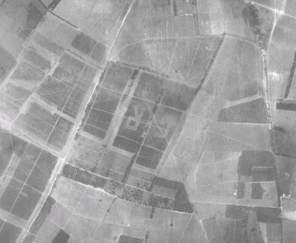
I also spotted a a very patriotic embellishment to the landscape just south of Thetford - see attachment
Of interest (to me at any rate) is that the Rushford Bombing Range is of a different date to that in the Norfolk Explorer. The key difference is the lack of the two strips at the base of the range arrow that signal individual aircraft. On the GE imagery they are missing which would indicate a later date than that shown, which seems to be a generic Mar 5 1945.
Attached files
This image is hidden for guests.
No Amount Of Evidence Will Ever Persuade An Idiot (probably not Mark Twain)
Replied by Peter Kirk on topic Google Earth thread!
Forgive me for being thick but I seem to have lost the 'go back button' - how do I find it?
It's only available in Google Earth version 5 upwards. If you have that you need the clock symbol in the toolbar (see screen grab)
This image is hidden for guests.
Please log in or register to see it.
I also spotted a a very patriotic embellishment to the landscape just south of Thetford - see attachment
Of interest (to me at any rate) is that the Rushford Bombing Range is of a different date to that in the Norfolk Explorer. The key difference is the lack of the two strips at the base of the range arrow that signal individual aircraft. On the GE imagery they are missing which would indicate a later date than that shown, which seems to be a generic Mar 5 1945.
Attached files
This image is hidden for guests.
Please log in or register to see it.
No Amount Of Evidence Will Ever Persuade An Idiot (probably not Mark Twain)
Please Log in or Create an account to join the conversation.
- WiganMick59
-

- Offline
- Senior Member
-

Less
More
- Posts: 234
- Thank you received: 1
11 Sep 2010 13:35 #48
by WiganMick59
........"Watch out for that ditch mick"...........OOps:)
Replied by WiganMick59 on topic Google Earth thread!
I'll be on here for ages...........top discovery Hal 
........"Watch out for that ditch mick"...........OOps:)
Please Log in or Create an account to join the conversation.
- kebecker
-

- Offline
- Platinum Member
-
Less
More
- Posts: 2942
- Thank you received: 508
11 Sep 2010 14:12 #49
by kebecker
Replied by kebecker on topic Google Earth thread!
Thanks PNK, for some reason I knew I had seen Rushford mentioned before. I was involved in some feild work in the mid 90s that took me there the quadrant tower was at the time reasonably accessble, look like the outdoor piggeries have limited access.
Please Log in or Create an account to join the conversation.
- Hal_Chase
-

- Offline
- Senior Member
-
Less
More
- Posts: 210
- Thank you received: 0
11 Sep 2010 16:36 #50
by Hal_Chase
Yeah it only popped up a day or so ago....I spent half my life pouring over GE so I guess now I've just lost the other half
Here's hoping they expand the areas....Grafton Underwood seems to be missing and Thurleigh seems to have just been cut off (censored?)...Little Staughton is a minter though
Replied by Hal_Chase on topic Google Earth thread!
am surprised I missed this, unless it is very new.
Yeah it only popped up a day or so ago....I spent half my life pouring over GE so I guess now I've just lost the other half
Here's hoping they expand the areas....Grafton Underwood seems to be missing and Thurleigh seems to have just been cut off (censored?)...Little Staughton is a minter though
Please Log in or Create an account to join the conversation.
- Forum
- Open Forum
- Miscellaneous Research Topics
- Research Material, Websites and Useful Links
- Google Earth thread!
Time to create page: 0.080 seconds