- Posts: 5026
- Thank you received: 440
- Forum
- Open Forum
- Miscellaneous Research Topics
- General Airfield or 20th Century Military Architecture Discussion Topics
- 200 yard Moving Target Ranges
200 yard Moving Target Ranges
- carnaby
-
 Topic Author
- Offline
- Platinum Member
-

Less
More
28 Jun 2009 22:55 #11
by carnaby
Plan A is always more effective when the problem you are working on understands that Plan B will involve the use of dynamite
Replied by carnaby on topic 200 yard Moving Target Ranges
Excellent Peter, I Googled 200 yard ranges and variations and got nowhere.
Another view of the Fort George site is here . From your data I believe Pembrey's was here
Theddlethorpe looks interesting. Can't find any traces - wonder if it was the Manby Turret Manipulation Trainer.
Incidentally if you stare at a section of coastal plain in Google Earth / Bing long enough it becomes a target range .
Graham
Another view of the Fort George site is here . From your data I believe Pembrey's was here
Theddlethorpe looks interesting. Can't find any traces - wonder if it was the Manby Turret Manipulation Trainer.
Incidentally if you stare at a section of coastal plain in Google Earth / Bing long enough it becomes a target range .
Graham
Plan A is always more effective when the problem you are working on understands that Plan B will involve the use of dynamite
Please Log in or Create an account to join the conversation.
- Peter Kirk
-

- Offline
- Moderator
-

Less
More
- Posts: 12446
- Thank you received: 1029
29 Jun 2009 05:58 #12
by Peter Kirk
No Amount Of Evidence Will Ever Persuade An Idiot (probably not Mark Twain)
Replied by Peter Kirk on topic 200 yard Moving Target Ranges
I'm not sure about Theddlethorpe either. It might be a different type as there are a lot of moving targets on various ranges.
No Amount Of Evidence Will Ever Persuade An Idiot (probably not Mark Twain)
Please Log in or Create an account to join the conversation.
- PETERTHEEATER
-

- Offline
- Platinum Member
-
Less
More
- Posts: 10905
- Thank you received: 772
01 Jul 2009 09:56 #13
by PETERTHEEATER
Replied by PETERTHEEATER on topic 200 yard Moving Target Ranges
Thanks PNK and Carnaby, you just solved a 45 year old mystery.
As another of my RAF Bomb Disposal jobs our Flight spent 6 months at Pembrey in the mid -60s 'clearing' 480 odd acres.
Apart from a lot of mortar round scrap on what had obviously been a practice site for the Army, the only 'explosive' item that we found was a 50 round belt of mixed .303 ammo. Various scenarios were put forward as to how it got there including it being thrown out from passing bombers.
From the location now identified I know that it was ditched from the Moving Target Range!
As another of my RAF Bomb Disposal jobs our Flight spent 6 months at Pembrey in the mid -60s 'clearing' 480 odd acres.
Apart from a lot of mortar round scrap on what had obviously been a practice site for the Army, the only 'explosive' item that we found was a 50 round belt of mixed .303 ammo. Various scenarios were put forward as to how it got there including it being thrown out from passing bombers.
From the location now identified I know that it was ditched from the Moving Target Range!
Please Log in or Create an account to join the conversation.
- PETERTHEEATER
-
- Offline
- Platinum Member
-
Less
More
- Posts: 10905
- Thank you received: 772
15 Jul 2009 09:46 #14
by PETERTHEEATER
Replied by PETERTHEEATER on topic 200 yard Moving Target Ranges
Take a look at WORKS (AP3236) Page 74 Plan 20 which shows a typical layout for a coastal Bombing & Gunnery Range.
Marked on it is a 200 yard Turret Range.
Assuming that this is an actual layout (as implied by the Lat/Long figures in the margins) where is it? The nearest I can get is Pembrey but the Lat/Long don't fit.
But then I was an Armourer not a Navigator
Marked on it is a 200 yard Turret Range.
Assuming that this is an actual layout (as implied by the Lat/Long figures in the margins) where is it? The nearest I can get is Pembrey but the Lat/Long don't fit.
But then I was an Armourer not a Navigator
Please Log in or Create an account to join the conversation.
- carnaby
-
Topic Author
- Offline
- Platinum Member
-
Less
More
- Posts: 5026
- Thank you received: 440
15 Jul 2009 14:36 #15
by carnaby
Graham
Plan A is always more effective when the problem you are working on understands that Plan B will involve the use of dynamite
Replied by carnaby on topic 200 yard Moving Target Ranges
I believe I once traced this Peter but memory is now out on this one. However you've just opened another can of worms - see hereTake a look at WORKS (AP3236) Page 74 Plan 20 ... where is it?
Graham
Plan A is always more effective when the problem you are working on understands that Plan B will involve the use of dynamite
Please Log in or Create an account to join the conversation.
- PETERTHEEATER
-
- Offline
- Platinum Member
-
Less
More
- Posts: 10905
- Thank you received: 772
16 Jul 2009 08:09 #16
by PETERTHEEATER
Replied by PETERTHEEATER on topic 200 yard Moving Target Ranges
Thanks Carnaby, I already looked at the other AP 3226 'where is it thread and gave a few answers.
But this one should be traceable given the grid numbers in the margins. Looking at it again, no 'degrees' are shown only 'minutes' and 'seconds' so I shall look between all the West Coast UK 'degree' points and see what I can find.
EDIT: OK, confirmed; it is Pembrey. The A/G target area shown on the plan (WW2) is much further down the beach than the present day RAF A/G target area. But, the Minutes and Seconds ties up.
But this one should be traceable given the grid numbers in the margins. Looking at it again, no 'degrees' are shown only 'minutes' and 'seconds' so I shall look between all the West Coast UK 'degree' points and see what I can find.
EDIT: OK, confirmed; it is Pembrey. The A/G target area shown on the plan (WW2) is much further down the beach than the present day RAF A/G target area. But, the Minutes and Seconds ties up.
Please Log in or Create an account to join the conversation.
- Paul Francis
-

- Offline
- Moderator
-
Less
More
- Posts: 5843
- Thank you received: 567
16 Jul 2009 21:06 #17
by Paul Francis
You can tell a builder from an archaeologist by the size of his trowel. Mine is a small one!
Replied by Paul Francis on topic 200 yard Moving Target Ranges
This is the army equivellent not from Okehampton Camp, Devon
This image is hidden for guests.
This image is hidden for guests.
Please log in or register to see it.
You can tell a builder from an archaeologist by the size of his trowel. Mine is a small one!
Please Log in or Create an account to join the conversation.
- PETERTHEEATER
-
- Offline
- Platinum Member
-
Less
More
- Posts: 10905
- Thank you received: 772
17 Jul 2009 06:51 #18
by PETERTHEEATER
Replied by PETERTHEEATER on topic 200 yard Moving Target Ranges
Just for NP, some similar Army moving target ranges a couple of kms SW of Carnoustie golf course:
This image is hidden for guests.
This image is hidden for guests.
Please log in or register to see it.
Please Log in or Create an account to join the conversation.
- PETERTHEEATER
-
- Offline
- Platinum Member
-
Less
More
- Posts: 10905
- Thank you received: 772
17 Jul 2009 07:05 #19
by PETERTHEEATER
Replied by PETERTHEEATER on topic 200 yard Moving Target Ranges
Identifying the Page 252 model may not be possible. A snatch from the text referring to the special camouflage for AME stations states: (Page 253)
'Models were used on an elaborate scale and proved invaluable in determing results before any site work was commenced. A complete 1/2500 model with vertical scale of 1/500 was constructed in considerable and precise detail. Based largely on an existing bomber station it included additional features of coastal AME stations, WT stations, dispersed bomb stores etc.'
However, the next paragraph says....it will be seen it is indistinguishable from the aerial photograph of an actual site and the bomb store site of the model, in its camouflaged state'
'The' aerial photograph implies that the photograph on Page 252 below the photograph of the model is an actual station.
Since I have all practically all the airfields and their bomb stores plotted and not that many were in wooded areas I shall keep looking until I find it or admit defeat.
'Models were used on an elaborate scale and proved invaluable in determing results before any site work was commenced. A complete 1/2500 model with vertical scale of 1/500 was constructed in considerable and precise detail. Based largely on an existing bomber station it included additional features of coastal AME stations, WT stations, dispersed bomb stores etc.'
However, the next paragraph says....it will be seen it is indistinguishable from the aerial photograph of an actual site and the bomb store site of the model, in its camouflaged state'
'The' aerial photograph implies that the photograph on Page 252 below the photograph of the model is an actual station.
Since I have all practically all the airfields and their bomb stores plotted and not that many were in wooded areas I shall keep looking until I find it or admit defeat.
Please Log in or Create an account to join the conversation.
- Peter Kirk
-
- Offline
- Moderator
-
Less
More
- Posts: 12446
- Thank you received: 1029
26 Jul 2009 14:24 - 09 Sep 2017 17:48 #20
by Peter Kirk
No Amount Of Evidence Will Ever Persuade An Idiot (probably not Mark Twain)
Replied by Peter Kirk on topic 200 yard Moving Target Ranges
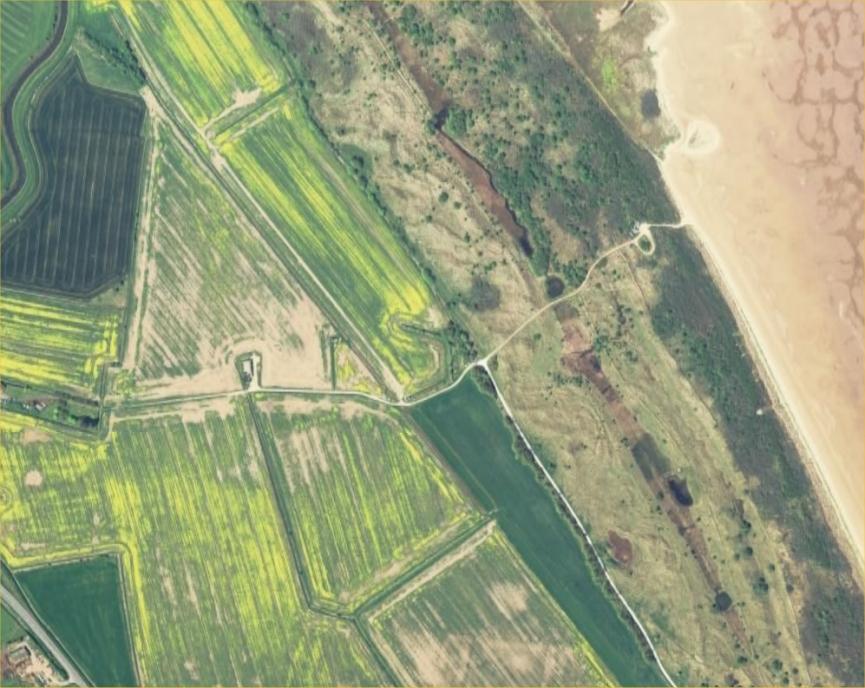
I have found the Theddlethorpe MTR. You have to search zoomed in as it is not apparent when zoomed out.
Attached files
This image is hidden for guests.
Attached files
This image is hidden for guests.
Please log in or register to see it.
No Amount Of Evidence Will Ever Persuade An Idiot (probably not Mark Twain)
Last edit: 09 Sep 2017 17:48 by netcompsys. Reason: fixed photos with filename spaces
Please Log in or Create an account to join the conversation.
- Forum
- Open Forum
- Miscellaneous Research Topics
- General Airfield or 20th Century Military Architecture Discussion Topics
- 200 yard Moving Target Ranges
Time to create page: 0.074 seconds